


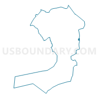
Voting District 3300050, Queens County, New York
About
Outline

Summary
| Unique Area Identifier | 635395 |
| Name | Voting District 3300050 |
| County | Queens County |
| State | New York |
| Area (square miles) | 0.12 |
| Land Area (square miles) | 0.12 |
| Water Area (square miles) | 0.00 |
| % of Land Area | 100.00 |
| % of Water Area | 0.00 |
| Latitude of the Internal Point | 40.68701840 |
| Longtitude of the Internal Point | -73.72838480 |
Maps

Graphs
Select a template below for downloading or customizing gragh for Voting District 3300050, Queens County, New York


Neighbors
Neighoring Voting District (by Name) Neighboring Voting District on the Map
- Voting District 0221032, Nassau County, NY
- Voting District 0221038, Nassau County, NY
- Voting District 0221089, Nassau County, NY
- Voting District 2900044, Queens County, NY
- Voting District 2900045, Queens County, NY
- Voting District 3300047, Queens County, NY
- Voting District 3300051, Queens County, NY
- Voting District 3300052, Queens County, NY
Top 10 Neighboring County Subdivision (by Population) Neighboring County Subdivision on the Map
Top 10 Neighboring Place (by Population) Neighboring Place on the Map
Top 10 Neighboring Elementary School District (by Population) Neighboring Elementary School District on the Map
- Elmont Union Free School District, NY (50,010)
- Valley Stream Union Free School District 30, NY (17,623)
Top 10 Neighboring Secondary School District (by Population) Neighboring Secondary School District on the Map
- Sewanhaka Central High School District, NY (117,965)
- Valley Stream Central High School District, NY (59,765)
Top 10 Neighboring Unified School District (by Population) Neighboring Unified School District on the Map
Top 10 Neighboring State Legislative District Lower Chamber (by Population) Neighboring State Legislative District Lower Chamber on the Map
- Assembly District 21, NY (132,039)
- Assembly District 29, NY (122,770)
- Assembly District 33, NY (115,034)
Top 10 Neighboring State Legislative District Upper Chamber (by Population) Neighboring State Legislative District Upper Chamber on the Map
Top 10 Neighboring 111th Congressional District (by Population) Neighboring 111th Congressional District on the Map
Top 10 Neighboring Census Tract (by Population) Neighboring Census Tract on the Map
- Census Tract 4099, Nassau County, NY (7,787)
- Census Tract 4098, Nassau County, NY (5,479)
- Census Tract 616.01, Queens County, NY (2,180)
- Census Tract 622, Queens County, NY (1,983)
- Census Tract 614, Queens County, NY (1,234)
- Census Tract 616.02, Queens County, NY (1,152)